
An overview…
Brixton Road leads from the Oval all the way down to Brixton, where it forms the high street and then forks into Effra Road and Brixton Hill. Brixton Road is an ancient road that dates back to the Roman era when it was part of the London to Brighton Way. It has previously been called ‘The way to Brighthelmstone”, Brixton Causeway, Bristow and the Washway. The River Effra used to be visible running alongside the road for much of it’s length, it has since been built over and confined to sewer. Fronting Brixton Road at the north end is the Neo-Byzantine style Christ Church, opened in 1902. For much of its length Brixton Road remains lined by Regency period terraces of houses that once made a virtually continuous frontage from Kennington to Brixton. These had become semi-derelict by the 1970s when some were replaced, but many were refurbished by the Greater London Council, mostly as social housing. The part of Brixton Road that falls within the boundaries of this website is what was once owned as part of ‘The Wright Estate’ and also part of ‘ The Lambeth Wick Estate’
On the Wright Estate British History Online tells us that “Nothing is known about the early history of the land between Prima Road, South Island Place, Clapham Road and Brixton Road. The area formed a no-man’s land bounded by the Manor of Kennington and Vauxhall Creek on the north, by Vauxhall Manor on the west and by Lambeth Wick Manor on the east and south. It may perhaps be identified with 18 acres h+eld by Robert Addison of St. Saviour’s, Southwark, butcher, who was presented in 1640 to the Court of the Commissioners of Sewers to scour the sewer which lay along his ground near Hazards Bridge. Hazards Bridge crossed Vauxhall Creek at the north end of Brixton Road. Development of these 18 acres started at the beginning of the 19th century but only along the frontages to the main roads. Prima Road, formerly Church Row or Street, was laid out about 1794, when the property belonged to John Wright of Esher, banker. Wright granted several building leases of plots fronting Clapham and Brixton Roads and a few of the houses erected under these leases survive”
The history of the Lambeth Wick estate is a little more documented in the annals of time, British History Online tells us that “The origin of the Manor of Lambeth Wick (Wyk, Wyke or Wykecourt) is obscure, but it seems to have been appurtenant to the Manor of Lambeth which was granted to Hubert Walter, Archbishop of Canterbury, by the Prior and Convent of Rochester in 1197. The earliest mention of it which has been found is in 1271, when “Lametheth with La Wyk” was in the king’s hands during the vacancy of the See of Canterbury caused by the death of Archbishop Boniface. In the chartulary belonging to St. Thomas’ Hospital there are grants of land “in Wike” and “at la Wyke”. Only one of these is dated (1338) and as no deeds relating to this land have survived among the hospital’s archives it is impossible now to identify it. In 1701 the Manor was let to Sir Stephen Fox, father of the first Baron Holland of Foxley and grandfather of the famous Charles James Fox; various members of the family continued as lessees of the property till the beginning of the 20th century. The estate was developed by Henry Richard Vassall, the third Baron Holland, who adopted his wife’s maiden name of Vassall in 1800. Holland Grove, Foxley, Vassall and Lilford Roads commemorate the family’s connection with the area.
Although an Act of Parliament was passed in 1807 enabling the Archbishop to grant building and repairing leases of this and other of his estates, the development of Lambeth Wick Manor did not start till 1820. This delay was probably due to the slow progress of the project which was first mooted in 1806 to build a bridge across the Thames at Vauxhall with connecting roads into Middlesex and Surrey . Such a scheme would and did have a tremendous effect on the development of Kennington and Brixton, and it seems likely that building in Lambeth Wick was delayed until it was known definitely what direction the new roads would take. Vauxhall Bridge was eventually opened in 1816 and two years later an Act of Parliament was passed providing for the formation of a road from the bridge foot to Camberwell, i.e., Harleyford Road and Camberwell New Road, the latter passing across the northern parcel of the Manor. The estate thus acquired valuable frontages to both sides of the new road, which was subsequently linked with the Brixton and Clapham Roads by Caldwell Street and Vassall Road.
Between 1820 and 1824 the whole of the Manor was let to Henry Richard Vassall, third Baron Holland, under 15 different building leases for terms of 99 years, due to expire by 1923. Building began first in the northern parcel of the Manor where prospects had been considerably improved by the opening of the Camberwell New Road. The frontages to Clapham, Brixton and Camberwell New Roads, and later to the new roads in between, were let in small parcels by Lord Holland to both builders and speculators for terms of 80 years. This policy of piecemeal letting, especially in the Brixton Road, resulted in unrelated groups of villas and terrace houses which, in spite of the charm of individual members, gave to the whole an untidy and haphazard appearance. In some cases the reserved rents of the plots sub-let by Lord Holland were sold by him for the duration of the sub-lease to persons not actively engaged in developing the property. This practice provided the vendor with fresh capital to re-invest in further development, while the purchaser of the rents and his dependants enjoyed an annuity for some time to come”
The River Effra….
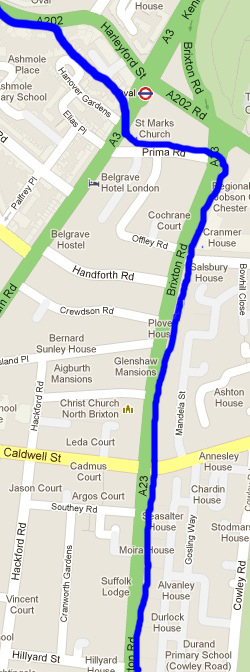
The above image roughly shows the course of the River Effra on a modern day map.
The Effra ran along the east side of Brixton Road, it was said to have been 12 feet wide and 6 feet deep. Bridges gave access to the houses that run parallel to Brixton Road, it must have been a very quaint and rural place to live. As well as Queen Elizabeth, Canute is said to have sailed up the river as far as Brixton – and King James I gave permission for the river to be opened up for navigation in this area.
At the top of Brixton Road was once Hazard’s Bridge, this bridge crossed Vauxhall Creek at the north end of Brixton Road. The land must have been very marshy at all times until the sewer was closed in, for the area around Kennington Common, the Oval and Claylands Road formed a shallow depression through which the river flowed, and indeed often overflowed. The Effra divided the manors of Kennington and Vauxhall. In 1880 when the river was built over the soil excavated was used to build banks for the spectators at The Oval to sit on. The Effra is now resigned to run it’s course as a sewer, it is still there however rushing under our feet, the same stream that Roman soldiers marched by and Anglo-Saxon kings sailed on.
Brixton Road On Maps…
1809
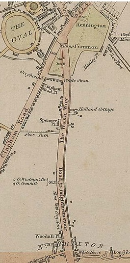
The map above is “Laurie and Whittle New Map of London with its Environs, including the Recent Improvements from 1809″ Brixton Road is labelled ‘The Washway’. The feint line that runs down the right hand side of it is the River Effra. Note the distinct lack of buildings alongside it, in 1809 Brixton Road was most definitely considered to be the countryside.
1820
The rather basic “Pigot & Co.’s Metropolitan Guide & Miniature Plan Of London from 1820″ shows Brixton Road and the surrounding area eleven years later.
1836
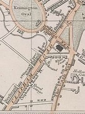
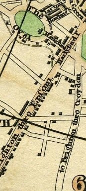
The above image is from a map produced in 1836 and is called ‘Plan of London & Westminster with the Borough of Southwark Being an index to the Large Plan in forty Sheets’ Brixton Road is still labelled The Washway.
1844
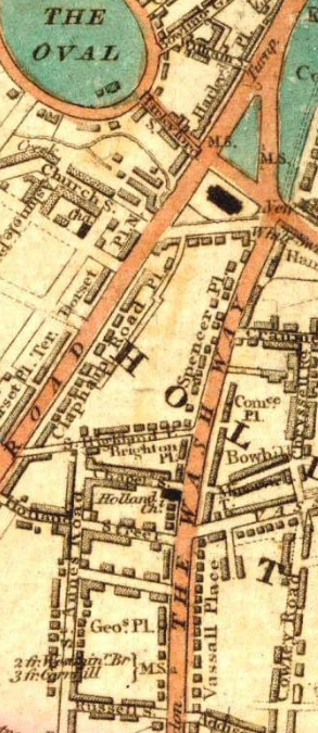
The above image is from a map produced in 1844 and is called ‘Laurie’s Map of London’ You can see that there are many more properties running alongside ‘The Washway’ than in the previous maps.
1850

Cross’s New Plan Of London 1850 shows Brixton Road as both ‘The Washway’ and ‘Brixton Causeway’
1861
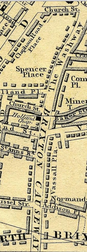
Cross’s New Plan Of London 1861
1876
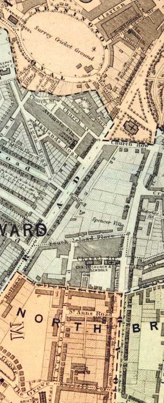
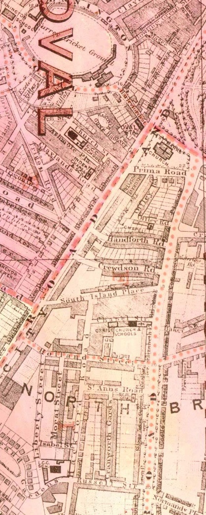
The map was produced to show the various Lambeth Wards in 1876. By this date Brixton Road was fully built up with houses and shops, although not indicated the Effra river was still flowing alongside Brixton Road and would be for another four years after the date of this map.
1898

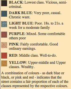
Charles Booth’s Map of London Poverty research took him to Brixton Road in 1895. The Map above is from 1898 and shows how Booth graded Brixton Road. For more information on Charles Booth and the classification of poverty see here. Booth graded Brixton Road in red which was ‘Middle Class, Well-to-do’.
1918
The above image is from another map produced to show the various Lambeth Wards, this time in 1918.
Trams ran along it…
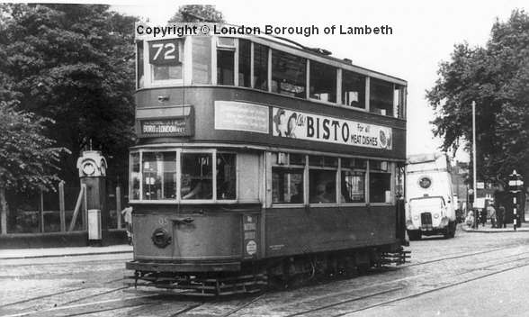
Brixton was connected to the tram system for over 75 years. At first the trams were horse drawn, starting in the 1870s, followed by cable cars in 1892 and finally electric trams from 1904. They ran the entire length of Brixton Road, see the image below for an idea of the tram network in 1914. They were eventually phased out in 1951 and replaced by buses.
For many years St Mark’s church opposite Oval Station was nicknamed ‘The Tramwaymen’s Church’ and you can see them gathering for a commemoration ceremony in this short clip from 1927. The Cable Cafe at number 8 Brixton Road was a favourite for tramwaymen and still retains the name to this day. More information about Trams on Brixton Road at the bottom of this page.
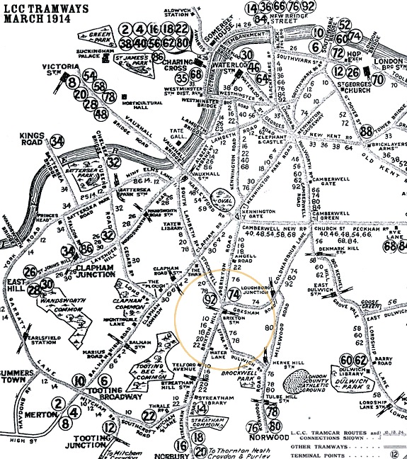
The tram network in 1914 (above)
An electric tram in 1950 passing St Mark’s Church
Brixton Road in photographs…
1905
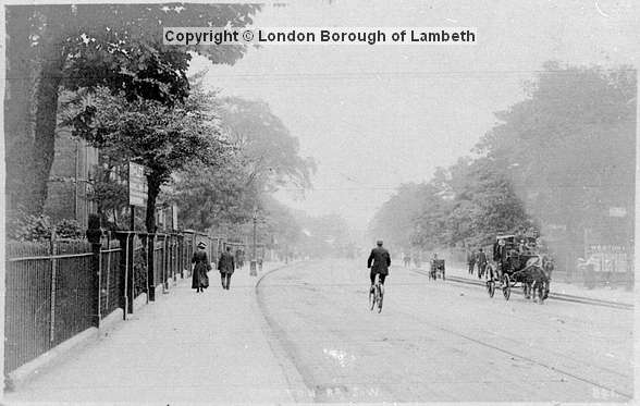
1912
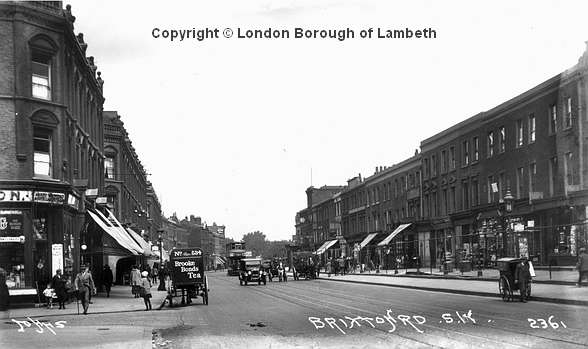
I’ve tried to capture roughly the same view as the photograph above but as it is today …
2012
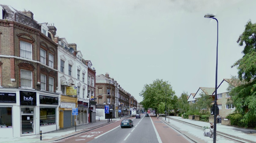
One hundred years later and you can see that the shops and flats above to the right hand side are almost unchanged whereas on the east side of the street there has been total demolition and modern buildings stand next to the wide raised pavement that is clearly visible on the 1912 image.
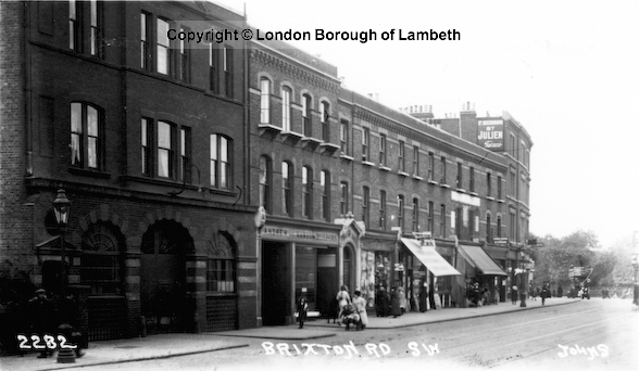
1912
As with the last 1912 photograph I’ve tried to capture roughly the same view as the photograph above but as it is today …
2012
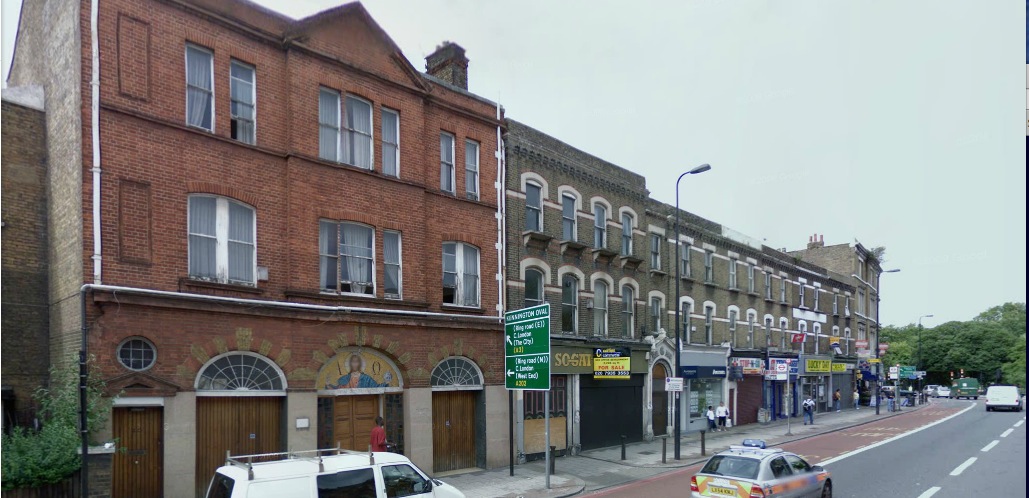
In the photograph above taken in 1912 Number 20 is at the far left, at the time an electricity sub-station it is now an Italian church. It was originally a cable tram depot.
Christ Church…
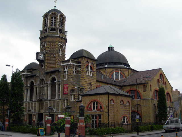
Anyone walking along Brixton Road will have noticed the rather unusual looking Christ Church dominating the skyline. Built in 1898-99 British History Online tells us…
“In 1823 the Rev. Dr. John Styles obtained a sub-lease from Lord Holland of a piece of land on the west side of Brixton Road on which he had recently erected Holland Chapel. At first the chapel was used for Independent worship, but about 1836 Dr. Styles and part of the congregation seceded and moved to a new chapel in Clay lands Road. In the 1840s Brayley described Holland Chapel as “a neat stuccoed edifice, with a bell-turret over the central part” and said that it had been a proprietary Episcopal chapel for some years.
Owing to the efforts of the Rev. J. McC. Hussey, who purchased the leasehold interest in 1854, the chapel became vested in the Church Building Commissioners, and was consecrated in 1855 and renamed “Christ Church”. Hussey gave the leasehold interest to the Commissioners and enlarged the chapel out of his own private funds. He also acquired the advowson and presented himself to be the first vicar; he held the living until his death in 1891. During the incumbency of the next vicar, W. R. Mowll, the chapel proved inadequate for the increased congregation. A printed appeal for funds reported that “The congregations attending the Church, more particularly on Sunday evenings, are immense; … The building has been packed from floor to roof; and … the adjoining Church Room has also been filled with eager listeners.”
Plans for a new church to accommodate 1,200 persons were provided by Professor Beresford Pite but were not finally approved until January, 1900. Meanwhile two houses at the rear of the church in Chapel (now Mowll) Street were purchased for the erection of a hall (also designed by Pite) which was to accommodate the congregation during the rebuilding of the church. The foundation stone of the new hall was laid on July 24, 1897, and the building was completed in 1899. The foundation stone of the new church was laid on December 13, 1898, by Princess Christian, and the old church was demolished in the following year. The house adjoining the old church in Brixton Road was also pulled down and the land on which it stood was incorporated in the site of the new building. At the same time a six-foot strip of land was given up for the widening of Chapel Street. The church was built by Alfred A. Webber of Mortimer Street, St. Marylebone, at a cost of about £17,000 and was consecrated by the Bishop of Rochester on December 5, 1902. The outside pulpit at the south-west corner was designed by Weir, Burrows and Weir and was erected without reference to Pite; it was dedicated on November 3, 1907.
More on Brixton Road across the site…
There is a really extensive look at the businesses that once occupied the west side of Brixton Road here: Brixton Road 1881 to 1928
Lots about Brixton Road in wartimes over on the Bombing & War section

I’ve just spread the word about your site to many friends on Facebook and Twitter who will be interested in the area where we all grew up. Do you know much about Cowley Road where I remember a small park and a shoe manufacturer at the junction with Mostyn Road in the mid 70s? Cancell Road and Christ Church School are of great interest as well…..Thanks agin for a great site.
Thanks for the kind feedback, glad you are enjoying the site! I’ve not got plans just yet to cover Cancell/Vassall/Cowley Roads, not until I’ve finished covering everything within my current website’s boundaries, I’ll let you know when I do begin covering those areas however as they clearly have a rich pot of history.
Chris
my dad said he saw trams when he came here 1950 ish i was bourn agu 1962
Gres, the park you mentioned, we called the ‘little Park’ and was opposite the Cowley Arms pub. I lived on Cowley Estate and did my first cloud gazing aged five in that park. I don’t recall the shoe manufacterer
Hi Gres, I lived on the Cowley Estate, from 1954 until 1970. Our flat was opposite the end of Cancell Road and I attended Christ Church primary, lovely little school. I remember the small park at the end of Cowley Road. Also used to play on bomb sites on Vassall Road.
Brixton Road has also featured in literature – No. 117 is the address of a character in Arthur Conan Doyle’s Sherlock Holmes’ story ‘The Blue Carbuncle’.
This is a great site, thank you!
Great site, thanks. Just to say, if not already mentioned, Charlie Chaplin and his brother Sydney had a flat at 15 Glenshaw Mansions, Brixton Road in about 1908.
I love this site, and I have only just found you. I have never seen the row of cottages where I was born on any map of Brixton. It was behind the shops in Brixton Road, Lipton’s, David Greig’s, Bendel’s sweet shop. It was off Robsart Street and it was called ANN’S PLACE. It was demolished long ago and all that remains is the green-tiled archway , also the spot is now marked by a men’s public toilet!!
Hello
I’m a descendant of the man in the hat outside his cutler shop.
Great site with good history of Brixton road neighbourhoods around
St Mark Church area
Fond memory’s of growing up at 156 brixton road in the 50s with mum dad and my 6 brothers and sister. We rented rooms as they were called back then on the upper floors
sharing a cooker on the landing with other room renters. im 65 now but remember it like it was only yesterday.
Went to durand school and cowley road school
Hi Antony. I lived at 178 Brixton Road in 1931-1940 but the house was demolished due to bomb damage after we had moved. I went to Hackford Road school from 1935-1939 with two older brothers Tony and Michael. The whole school was evacuated just before war was declared and we were sent to Brighton. Do you know anyone who might still be around? I’m 92 and have 3 sons, 6 grandchildren and one great grandchild and they want me to write about my life particularly my childhood. I hope to contact Brixton Library to see what records they have. Sheila
Me and my sister used to live in Leys Court Brixton road but we was wondering what was there before Leys Court. We’ve been told that there were houses there in 1864. I was wondering if there are any pictures of the houses. Thank you.
my dad said he saw trams when he came here 1950 ish i was bourn agu 1962
Hi I’m researching an old Aston Martin car that was registered to an address in Brixton Road, I have just found this page and it looks very interesting, would be good to hear from you, you might be able to help in my research, thanks Martin
Does anyone know a lady called Betty who had a daughter called Jackie. Jackie attended my parents wedding in February 1962 she looked about five. Her mum babysat my sister Cherril for my parents who came from Barbados. Also does anyone know Ms Hurley? She had a house on Brixton Road towards the oval end and she let out rooms to Caribbean guys who came to the U.K. to work on the London Transport.
Did anyone on this website live at 14 Mostyn Road, Brixton? The house was emptied around 1970 because it was a fire hazard and needed to be condemned. Mostly people from abroad lived there in a couple of rooms each, we had a cooker outside the bedroom door. My parents lived there with three children in two rooms, sharing the bathroom and cooker.