1. Introduction
2. A River Ran Across It – The Effra
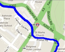
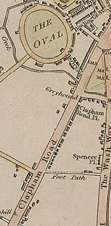
3. Clapham Road On Maps
4. Clapham Road in photographs
5. Oval Station
6. St Mark’s Church
7. The Belgrave Hospital for Children
8. Trams
9. 139 Clapham Road/Causton’s/Freeman’s/The Printworks
10. Listed Buildings Along Clapham Road
An overview…
Clapham Road runs from Oval Underground station to Clapham High Street and was originally an ancient Roman military road called Stane Street. It became known as the Merton Road as it led all the way though Clapham, Balham and Tooting to Merton. The road existed for many hundreds of years as a wide rural lane on which coaches from southern parts of the country travelled to the City. In Georgian times City merchants began to build grand houses alongside Clapham Road and smart thinking businessmen built coach houses for those travelling by horse and cart on their long journey into London.
Regarding the very north part of Clapham Road, British History Online tells us that “Nothing is known about the early history of the land between Prima Road, South Island Place, Clapham Road and Brixton Road. The area formed a no-man’s land bounded by the Manor of Kennington and Vauxhall Creek on the north, by Vauxhall Manor on the west and by Lambeth Wick Manor on the east and south.” Clapham Road has seen many buildings come and go, wartime damage being the main cause for this, however it has remained a mixture of houses and businesses into modern times and although it has a rather disorganised frontage there are many buildings of interest and a few of grandure still remaining.
A river ran across it…
The Effra ran along the east side of Brixton Road, it was said to have been 12 feet wide and 6 feet deep. Bridges gave access to the houses that run parallel to Brixton Road, it must have been a very quaint and rural place to live. As well as Queen Elizabeth, Canute is said to have sailed up the river as far as Brixton – and King James I gave permission for the river to be opened up for navigation in this area.
At the top of Brixton Road was once Hazard’s Bridge, this bridge crossed Vauxhall Creek at the north end of Brixton Road. The land must have been very marshy at all times until the sewer was closed in, for the area around Kennington Common, the Oval and Claylands Road formed a shallow depression through which the river flowed, and indeed often overflowed. The Effra divided the manors of Kennington and Vauxhall. At the north end of Clapham Road the Effra was crossed by a small bridge called Merton Bridge. This was so named after the monks of Merton Abbey who were responsible for the maintenance of it and all other bridges that crossed the Merton Road.
In 1880 when the river was built over the soil that was excavated was used to build banks for the spectators at The Oval to sit on. The Effra is now resigned to run it’s course as a sewer, it is still there however rushing under our feet, the same stream that Roman soldiers marched by and Anglo-Saxon kings sailed on.
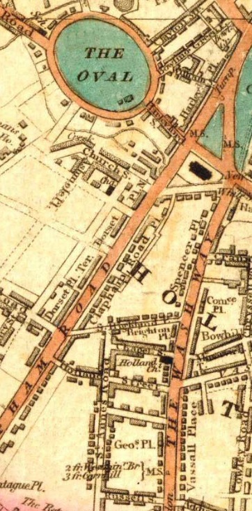
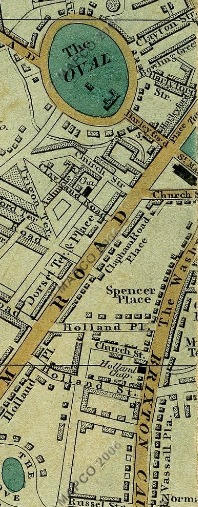
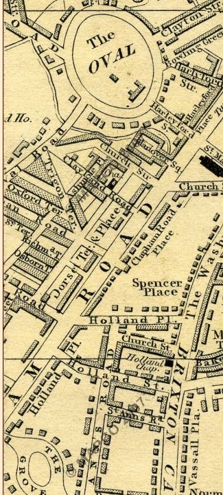
Clapham Road on maps…
1809
The map above is “Laurie and Whittle New Map of London with its Environs, including the Recent Improvements from 1809″ Clapham Road is clearly labelled. Note the distinct lack of buildings alongside it, in 1809 Clapham Road was most definitely considered to be the countryside.
1820

The rather basic “Pigot & Co.’s Metropolitan Guide & Miniature Plan Of London from 1820″ shows Clapham Road and the surrounding area eleven years later.
1837
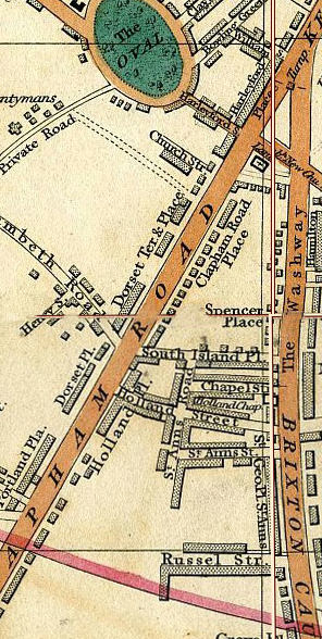
The above image is from a map produced in 1837 and is called ‘Cary’s New Plan Of London And Its Vicinity’. You can see that more buildings have popped up alongside Clapham Road, most of them built in blocks with their name ending in ‘Place’ some of which still stand today.
1844
The above image is from a map produced in 1844 and is called ‘Laurie’s Map of London’
1850
Cross’s New Plan Of London 1850
1861
Cross’s New Plan Of London 1861
1876
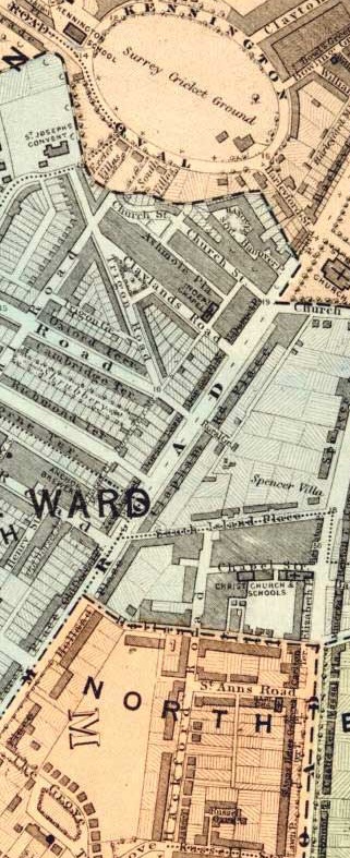
The map was produced to show the various Lambeth Wards in 1876
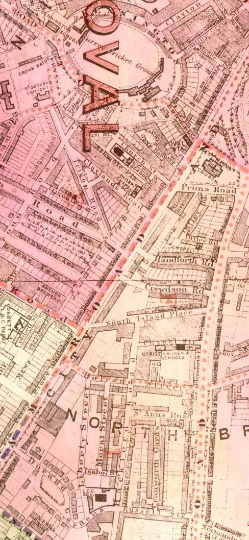
1895
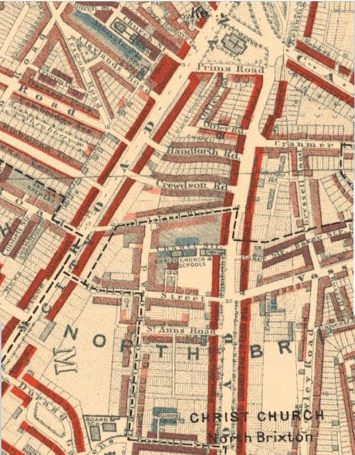
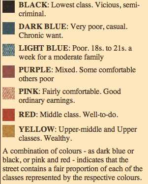
Charles Booth’s Map of London Poverty research took him to Clapham Road in 1895. The Map above is from 1898 and shows how Booth graded Clapham Road. For more information on Charles Booth and the classification of poverty see here. Booth graded Clapham Road in red which was ‘Middle Class, Well-to-do’.
1918
The above image is from another map produced to show the various Lambeth Wards, this time in 1918.
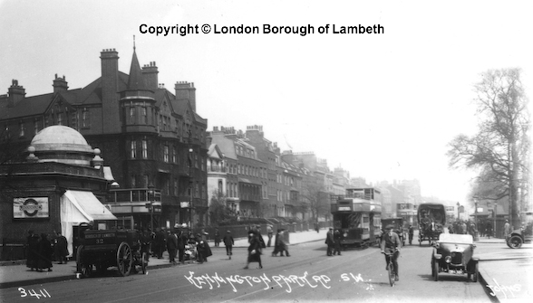
Clapham Road in photographs…
1914
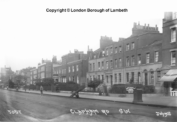
Clapham Road in 1914. A fine line of Georgian houses stands to the right. Note the tram tracks in the middle of the road.
2012
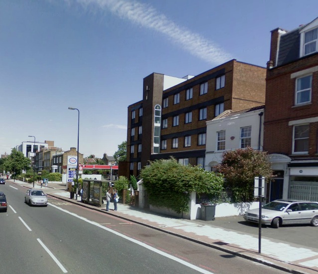
Roughly the same view as in 1914. Note the tram tracks have gone, as have several of the fine Georgian houses thanks to WW2. In their place stands St Monica House, a nunnery and guest house as well as a petrol station which looks particularly incongruous with it’s surroundings.
1914
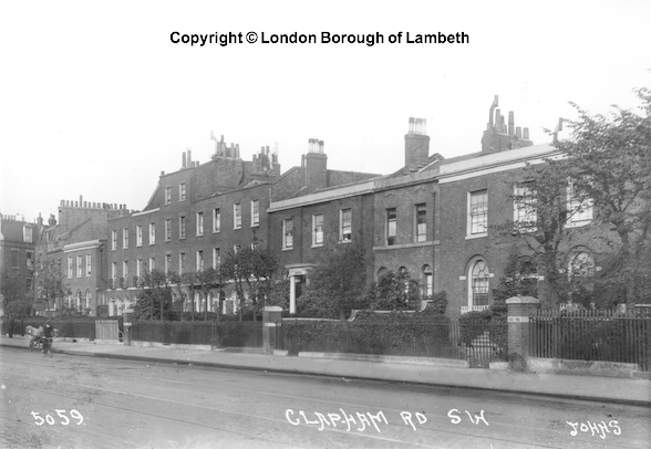
Another view of Clapham Road in 1914, it follows on from the 1914 image above, showing the long gone Georgian houses that once stood between the turn in to South Island Place and Caldwell Street.
2013
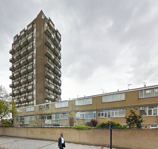
Roughly the same view as the 1914 image above. The original row of houses is long gone. Replaced in 1969 by the low rise Whitebeam Close seen above.
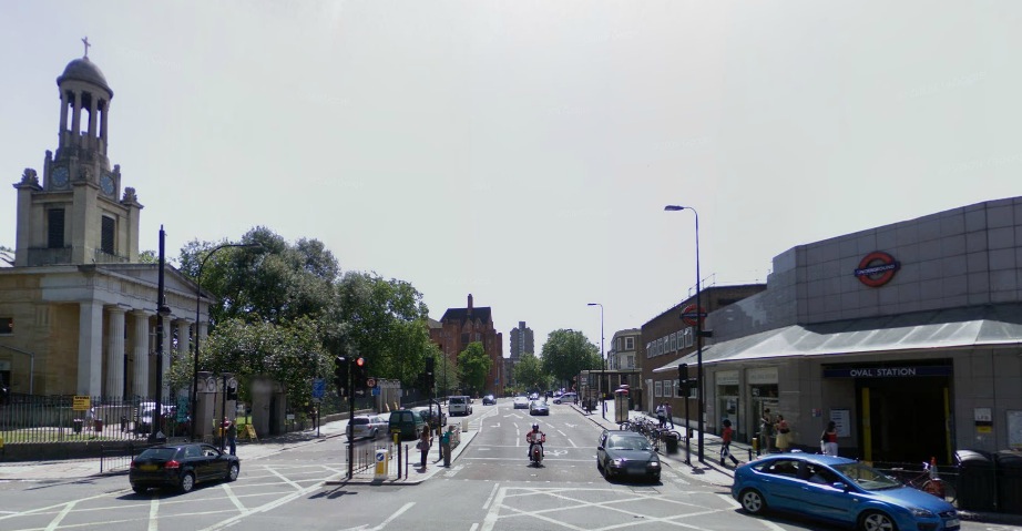
Oval Station…
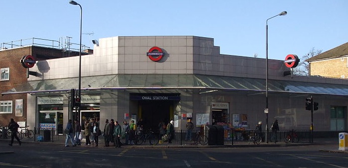
There were two transport portals that were responsible for the radical development of the area within my project boundaries, the first was Vauxhall Bridge, the second The City and South London railway. The line opened to passengers between Stockwell and King William Street on 18 December 1890, and was both the first standard gauge tube and the first railway to employ electric traction in London. To avoid disturbance of surface buildings the tube was shield-driven at deep level, and much of the work was done via shafts at station sites which later contained the passenger lifts. The Oval station, opened as Kennington Oval, was designed by Thomas Phillips Figgis with elements of early Arts and Crafts and neo-classical detailing. The structure was made distinctive by a lead-covered dome with cupola lantern and weathervane which housed some of the lift equipment; the main part of the building was of red brick.
The station building was rebuilt in the early 1920s when the line was modernised and was refurbished during late 2007/early 2008 at street level with a modern tiling scheme inside and out, giving the station a more modern look. Reflecting its proximity to the cricket ground, the internal decorative tiling features large images of cricketers in various stances. There is a popular urban myth which states that during World War 2 the government attempted to build a deep level shelter under Oval station however plans were thwarted when the long buried river Effra made an appearance and flooded every attempt to find a safe spot to dig. In reality this is not at all the case, the government did indeed begin work on a deep level shelter below the station however the work was abandoned as there were not enough people to undertake the work at the Camden Town shelter and so the workforce was sent there. This was due to many of the eligible workers being called up to fight and nothing to do with the Effra. The work on the shelter officially ended in December 1941 and the shafts that they had started were filled with concrete in 1944.
Oval tube station was the intended site of one of the attempted London bombings on 21 July 2005.
Oval Station in 1912 with the traditional domed roof, the kind that can still be seen on Kennington station one stop up the Northern Line. All of the buildings to the right of the station are long gone and replaced by a huge housing estate.
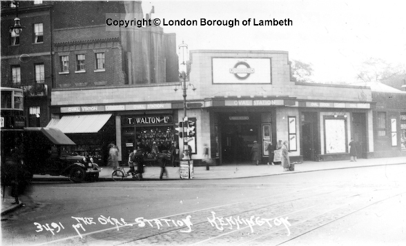
Oval Station after a total rebuild of the surface building in 1936.
St Mark’s Church…
The following excerpt is from the St Mark’s Website, all copyright belongs to them…
“St Mark’s Church is on the site of the old Roman Road Stane Street, which ran all the way from the Roman London Bridge to Chichester, via the gap in the North Downs at Box Hill.
From the 1600s, the area where St Mark’s is now situated was Kennington Common. The Common was notorious as a place for public executions, including the execution of Jacobite rebels in 1745. It was also the site of large public fairs and boxing matches and the Common gained a riotous, dissolute reputation.
Because of the huge numbers of people who congregated on the Common, it attracted large numbers of public speakers. In 1739 these included the radical Anglican clergyman (and Methodist pioneer) George Whitefield, who preached nightly to crowds of up to 30,000 in the open air. In fact, in Whitefield’s diary entry for Sunday 5 May 1739, he estimates the crowd at no less than 50,000. The 25-year-old preacher had quickly gained a reputation as the greatest orator of his day and some people clearly travelled a great distance to hear him. Dozens of horse-drawn coaches could be seen parked along the edge of the Common. Later that year, fellow Methodists John and Charles Wesley also became regulars on Kennington Common, attracting crowds of comparable size.
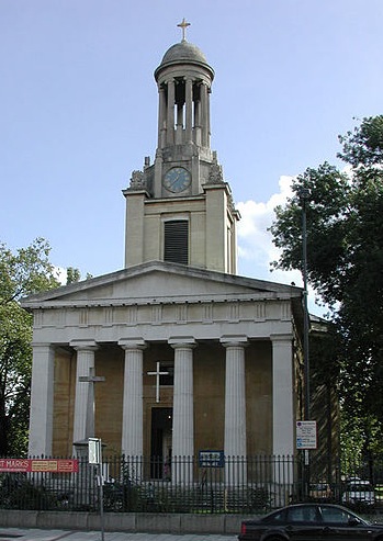
In 1824 St Mark’s Church was built on the old gallows corner of Kennington Common, one of four ‘Waterloo’ churches built in south London following the defeat of Napoleon at the Battle of Waterloo. Each was named after one of the four gospel writers: St Mark’s, Kennington; St John’s, Waterloo; St Luke’s, Norwood and St Matthew’s, Brixton. The church cost £16,093 4s 3d, and was opened by the Archbishop of Canterbury on 30 June. The first vicar of St Mark’s was the Rev William Otter, later Bishop of Chichester.
On the right of the engraving by WH Prior is the road to Lambeth with the Horns Tavern on the corner (far right of picture). The Tavern was a popular 18th and 19th century meeting place. In the distance is the new St Mark’s Church, on the site of the old Kennington Gallows. In front of St Mark’s is the Kennington Toll Gate.
In the 1850s, Kennington Common was enclosed and Kennington Park created. In the late 19th century the vicar of St Mark’s was the Rev Henry Montgomery, later to become Bishop of Tasmania. The fourth of the Montgomerys’ nine children (born in 1887) gained international fame during World War II as ‘Monty’, Field Marshal Montgomery. St Mark’s Mongtomery Hall is named in his memory. Another local resident in the early 20th century was the young Charlie Chaplin, who lived with his mother in a number of homes in and around Kennington Road.
During the Second World War the area was heavily bombed and St Mark’s suffered serious damage. The only parts to survive were the Grecian facade and pillars, topped by the small cupola and cross. The vicar of the day was the Rev John Darlington, who had been in post for 50 years (and still used to wear a top hat and tailcoat to church). Darlington died in 1947 while the church was still a ruin. Southwark Diocese had earmarked the remains of St Mark’s for demolition. But after seven years of dereliction, the Rev Wallace Bird obtained permission from the Archbishop of Canterbury, patron of the parish and close neighbour of St Mark’s at nearby Lambeth Palace, to rebuild both the buildings and the congregation.
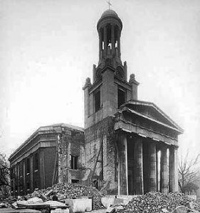 St Mark’s in ruins
In 1960 the restored St Mark’s was opened. By the 1980s St Mark’s Kennington had become one of the best known and most influential churches in Britain, under the inspirational leadership of the Rev Nicholas Rivett-Carnac.
A busy south London crossroads formerly notorious for death and vice has become a place of life and renewal”
The Belgrave Hospital for Children…
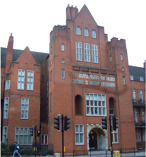
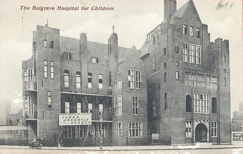
The Belgrave Hospital for Children at 1 Clapham Road, is a big imposing building with a high gable and mullioned windows. It is made of red brick with mosaics around the entrance. Even if you didn’t know the names Charles Holden or Percy Adams, you’d soon realise that the architects were influenced by the Arts and Crafts movement and it’s no surprise to find the building is Grade ll listed.
British History Online tells us
“This hospital was founded in 1866 in Pimlico. (ref. 4) At the end of the 19th century the Governors decided that the need for hospital accommodation in south London warranted its removal from Gloucester Street, Pimlico, and in 1899 they took a lease of its present site from P. E. Sewell. (ref. 5) The buildings which then occupied the site were pulled down and the foundation stone was laid by Princess Henry of Battenberg on June 27, 1900. (ref. 6) The east wing, centre block, out patients’ department and the ground floor of the south wing were finished in 1903 (ref. 4) and opened on July 20 of that year. (ref. 7) The south wing was completed in 1924 and the west wing two years later. (ref. 4) The plan of the hospital was the work of H. Percy Adams, but the elevations, which show the influence of Philip Webb, were prepared by Charles Holden, who had joined Adams in October 1899. (ref. 8) The builders were Messrs. Gough and Co. of Hendon. (ref. 9)
The hospital has a simple cruciform plan and is symmetrically arranged about the Clapham Road front. The building, which is mostly of four storeys, is faced with red brick and has mullioned and transomed windows of Portland stone. Its entrance wing at the centre is surmounted by a steep gable flanked by low square battlemented towers, and the wards in the north and south wings are galleried, with plain towers at each corner containing necessary services.”
In a 1994 article for the Independent entitled ‘The price of poshness’ David Clement Davies writes…
“The huge Edwardian Grade II listed building looms on the Oval skyline like an Addams Family film set. At the beginning of the Eighties, cutbacks at the hospital sparked local protests and demonstrations outside Downing Street. But the graffiti was already on the wall. It was closed in 1985 and became a political hot potato with various abortive schemes for its use, including a hall of residence and an Aids hospice.
The increasingly grimy building gained a new celebrity in 1989 when it was occupied by the Belgrave Homeless Project. It aspired to be more than a squat. The area was leafleted and banners went up in an attempt to highlight the plight of the homeless. For a time the occupation won considerable local and media support.
More than 150 people were housed there and Lambeth Council and the Brixton Council of Churches paid for electricity and running water. But just as the building around it began to decay, this attempt at self-help in the community gradually collapsed amid a growing number of horror stories. After a fire, the numbers dwindled to 40. The project for the homeless became a centre for drugs and the police began to give the place a wide berth. It was finally emptied after the murder of a former school teacher there in 1991″
You can read more of the article here.
 The Belgrave in 1903 just before it opened, note the right hand side is yet to be built.
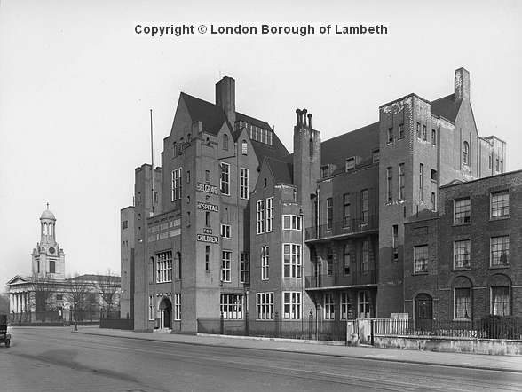
The Belgrave in 1928, note the Georgian houses to the right which are now demolished and the site occupied by the Belgrave hotel.
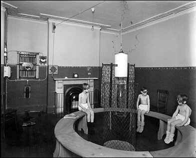
Children undergoing pioneering ‘light therapy’ in the light room (date unknown).
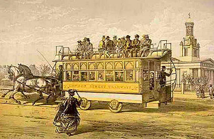
Trams ran along it…
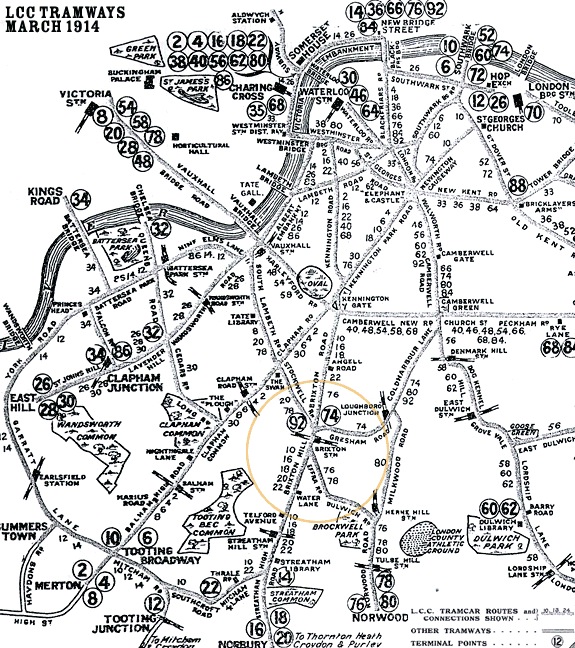
Brixton and Clapham were connected to the tram system for over 75 years. At first the trams were horse drawn, starting in the 1870s, followed by cable cars in 1892 and finally electric trams from 1904. They ran the entire length of Clapham Road, see the image below for an idea of the tram network in 1914. They were eventually phased out in 1951 and replaced by buses.
For many years St Mark’s church was nicknamed ‘The Tramwaymen’s Church’ and you can see them gathering for a commemoration ceremony in this short clip from 1927.
139 Clapham Road…
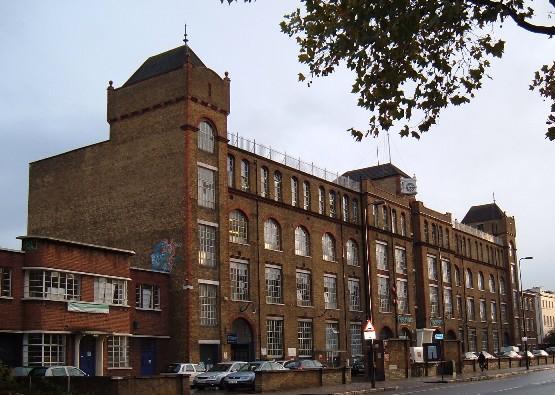
139 Clapham Road is now home to The Printworks, a new development which converted this grand old factory into modern flats and office space. However before anything stood on this plot of land it was occupied by, of all things, an 1800 foot roller skating rink and athletics space called The Marble Rink which opened in 1878.
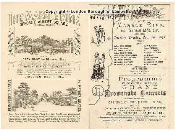
The space took on a multi-purpose entertainment venue role shortly after opening. On 20-25 June 1881 a 6 day non stop roller skating race took place, that must have took quite some stamina.
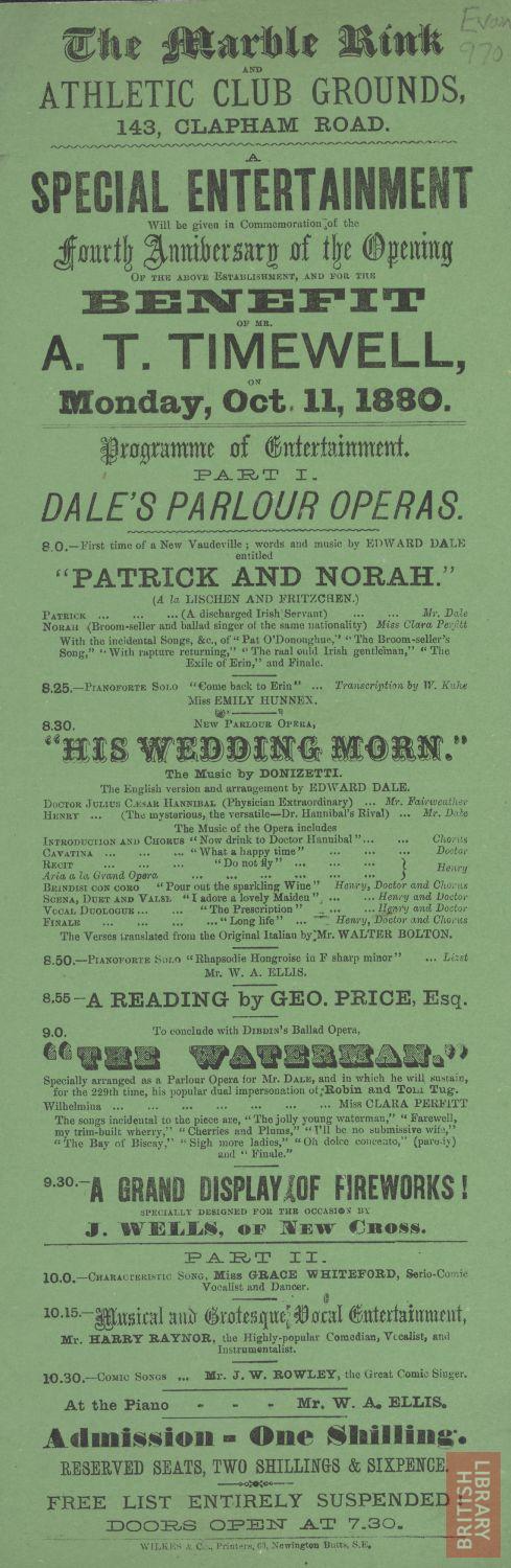
Handbill for the Marble Rink. Copyright © The British Library Board
The Marble Rink fell out of popularity as tastes changed and the site acquired by Sir Joseph Causton where in 1903 he built a huge printworks which still stands today.
Joseph Causton was a politician, becoming a Councillor for Billingsgate, East London in 1868 and Sheriff for London and Middlesex in 1868. The pinnacle of his career came when Queen Victoria opened Blackfriars Bridge and Holborn Viaduct in 1869 and he was knighted at Windsor Castle to mark the event. The company name then became Sir Joseph Causton and Sons Limited. Sir Joseph died just two years later, but his sons, Joseph, Richard, and James, continued as partners of the firm.
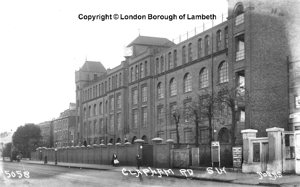
The Printworks in 1914
Causton’s were one of the UK’s biggest printing firms and made labels for household brands including Marmite and Guiness. Then in 1937 they moved away to Hampshire and the building was acquired by Freeman’s Catalogue Ltd. Freemans had started trading in 1905, making it one of the oldest catalogues in the UK. It began in a two room terraced house in Lavender Sweep, London by Arthur and Stanley Rampton, William Jones and Henry Freeman. It was during the mail order boom time in the 1930s that it moved to 139 Clapham Road which they renamed Lavender House. Freeman’s was by then the largest mail order business in Great Britain; larger than all its competitors put together. Some of its 30,000 agents managed to buy cars and houses with their commission money. Freeman’s added a substantial number of new buildings around Causton’s original centre structure, letting out parts of the site to other companies such as a donut factory in a little art-deco building once attached to left hand side of the frontage.
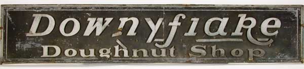
The Doughnut Corporation of America (DCA) established a subsidiary in the UK under the name of the British Doughnut Company. It made American type ring doughnuts and distributed them by tricycle to catering outlets in the area around their premises in Clapham Road. They were known as Downyflake Doughnuts. It also imported doughnut making machines from the US which were sold to bakers and caterers together with doughnut mixes which were blended in the Clapham Road factory. See here and here for images of the doughnut factory before and during demolition.
During World War 2 a tragedy struck and the building took a direct bomb hit killing 23 young women, you can read more about this incident in the Bombing and War section of my website here.
Following the business’s relocation to West Yorkshire, the Freemans building and surrounding site has been redeveloped by Galliard Homes as housing and business units. Two new streets that run either side of the original building have been created: Lett Road and Printer Road.
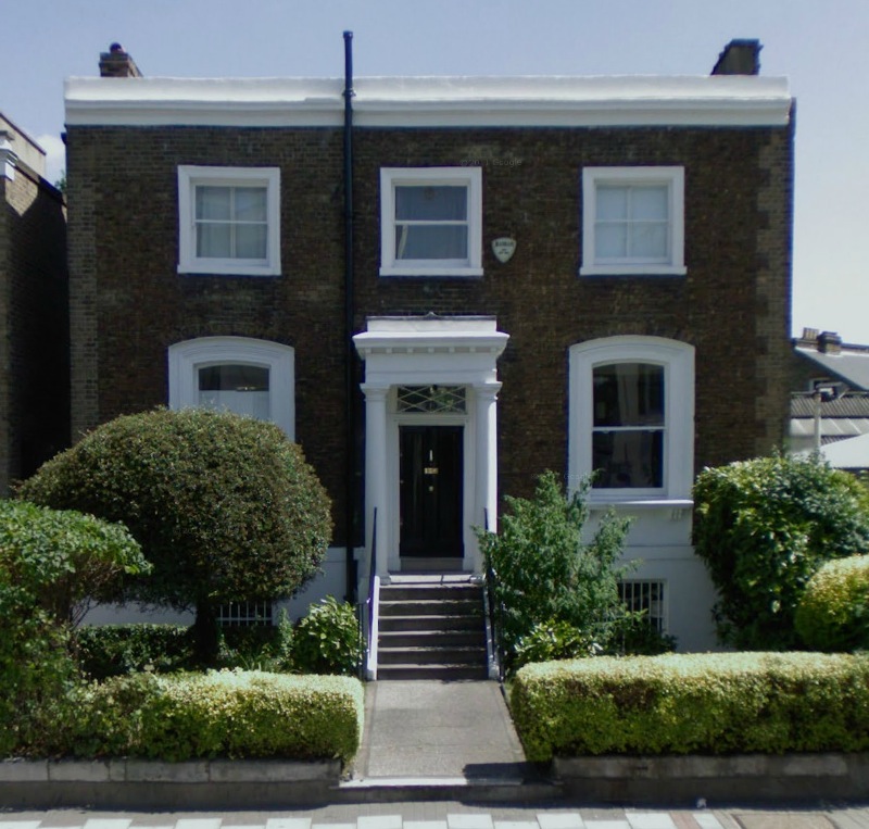
Nos. 13 and 15 Clapham Road…
It appears that number 13 is no longer standing and the site occupied by part of the Belgrave hotel, number 15 is still intact and is the centre three story house in the image above.
British History Online documents the history of these houses:
“Nos. 13 and 15 Clapham Road
Formerly Nos. 4 and 5 Clapham Road Place or Lambeth Place
A plan on the lease of the adjoining property dated 1805 shows these houses on lease to Henry Wood, (ref. 2) who may have erected them about this time. They are paired three-storey houses and have a stock brick front of simple design. A narrow recession defines the party wall between the houses, each of which has two rectangular windows in each storey. Those to the ground floor are set in shallow recesses with arched heads rising from moulded imposts. Each house is flanked by a single storey annexe containing the entrance, the door being set with a radial-patterned fanlight in a segmental-arched opening.”
The building is also listed, British Listed Buildings lists Number 15 as:
“Grade II listed. Early C19 house of 3 storeys and sunk basement, 2 windows with one-storey right entrance bay. Stock brick with stone-coped parapet having some rebuilding.
Gauged flat brick arches to sash windows with glazing bars, those on ground floor in round-arched recesses with stuccoed impost string. Modern 6-panel door with narrow side lights, cornice head and radial fanlight under segmental gauged brick arch with impost string across bay. Stuccoed basement.”
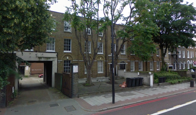
Nos. 17 to 25 Clapham Road…

British History Online documents the history of these houses:
“Nos. 17–25 (odd) Clapham Road
Formerly Nos. 6–10 (consec.) Clapham Road Place
These houses were erected in 1805 at the costs of James Medland of St. Mary Newington, surveyor, and were let to him in that year by John Wright’s trustees. (ref. 2) They are a terrace of five houses sharing a stock brick front that presents a balanced composition. All the houses are three windows wide and each end house forms a slightly projecting pavilion, four storeys high, the last being an attic above the mutule cornice. The three intermediate houses are three storeys high, and the cornice is surmounted by an open balustrade. A bandcourse marks the first-floor level. The windows generally are rectangular excepting those to the ground floor, which have flat segmental heads. Each house has a wood doorcase of simple design, except for No. 21 where the stucco surrounds are later.”
Nos. 27 to 33 Clapham Road…
British History Online documents the history of these houses:
“Nos. 27–33 (odd) Clapham Road
Formerly Nos. 11–14 (consec.) Clapham Road Place
No building lease of these houses has survived, but again by comparing the leases of adjoining houses it can be deduced that their site was on lease to Head, (ref. 10) probably William Head, a local builder (see page 76), in 1805. These are paired houses similar to Nos. 13 and 15, but with twoleaved doors and elaborated parapets to the annexes, which are now heightened or altered. The ground floor of No. 27 has been partly cut away to provide access to the rear, and the upper part of No. 29 has been rebuilt.”
Nos. 35 to 41 Clapham Road…

British History Online documents the history of these houses:
“In 1809 the trustees of John Wright, then deceased, let the whole of the frontage of Clapham Road between and including the site of No. 35 and the site of the present South Island Place, on building lease of 80½ years. (ref. 3) The lessees were the trustees of Richard Wooding, surveyor, who probably had an agreement for the building lease before his death in 1808. The trustees included Mary, wife of Richard Wooding, his executor Robert Roberts, who was also a surveyor, and Isaac Bates of Kennington, brickmaker (see page 21). Nos. 35 and 37 are built of stock brick, three storeys high, and form a six-bay block with end bays recessed and containing the doorways. The upper windows are square-headed and on the ground floor round-headed in shallow arched recesses, which, like the arched entrances, have rectangular impost blocks. Nos. 39 and 41 are a pair of three-storeyed stock brick houses with semi-basements. The two ground-floor windows and the entrance to each house are round-headed and recessed beneath shallow arches springing from moulded imposts. Above, the windows are rectangular, two to a storey, and there is a sillband at first-floor level. The doorcases have pilasters with reeded panels, capped by wreathed blocks. The street railings to No. 41 remain in part. They are spear-headed, the principal uprights having elegant urn finials.”
Nos. 61 to 75 Clapham Road…
British History Online documents the history of these houses:
“Nos. 63–73 form a symmetrical group of three linked pairs, the centre pair being considerably larger than the other two. No. 61 is nearly identical with the right-hand house in either of the smaller pairs, but has suffered some alteration. All are built of stock brick, of three storeys raised on a rendered semi-basement. Nos. 67 and 69, the centre pair, have each three windows to a floor, square-headed upstairs and round-headed on the ground floor where they are set in arched recesses with moulded imposts, to match the entrance. Both their doorways have plain fanlights and are flanked by very slender Roman Doric columns. No. 69 retains its original frieze, cornice and blocking course. Nos. 63 and 65 and Nos. 71 and 73 are flanked by one-storey links containing the doorways and each house is two windows wide. Otherwise they are treated in the same way as the centre pair. No. 75 is a two-storey stock brick house with a semi-basement, its front finished with a cornice and blocking course. It is three windows wide and there is a centrally placed porch resting on columns. The basement is faced with stucco.
Number 75 Clapham Road
Number 75 is also a listed building. British Listed Buildings lists Number 75 as:
Grade II Listed. Mid C19 villa of 2 storeys and basement, 3 windows. Stock brick with lighter brick quoins (perhaps once stuccoed?). Stucco basement with incised lines, frieze, cornice and blocking course. Moulded architraves to ground floor sash windows in segment-headed stuccoed recesses, and with projecting bracketed cills. Six steps (rebuilt) with wrought iron rail to door of 2 long panels in panelled reveal with fluted architrave and oblong fanlight, in prostyle Tuscan porch.
I found this extremely interesting. My family and I lived at No. 69 for over 50 years and my uncle and his family at No. 61. I worked at Freemans at No. 139 for 20 years. I still have very fond memories of my life there.
Many thanks for your kind words on my website, it’s great to hear that you found it interesting. When you say that you and your family lived at 69 and 61 do you mean Clapham Road?
I’m expanding the website to add a part about local people’s memories of the area, if you have any comments/memories/interesting facts I’d love to hear them so do let me know. What was it like working at Freeman’s? Did you ever encounter it’s alleged ghosts?
Best wishes
Chris
My grandmother and her father (Schmittdiel) had a bakery at number 27 Clapham Road in the 1911 census.I wonder if the Street has been re numbered since then?
Hi,
This site is so interesting! I’m particularly interested in the old photo above of the Georgian houses. As it happens I’m about to move into one of them, looks like its the only one still standing in the new photo. In the new photo it’s the one painted white, and in the old photo it seems to be a shop or business of some sort, judging by signage on the windows. Do you happen to know anything about this building? It’s number 89, next to St. Monica’s. Would love to know how old it is or what it used to be. If not, could you tell me where you got the old photo from? Keep up the good work!
I really enjoy this site. 15 Clapham Road is still a council house.. I lived there from 4yrs old until 22. I really enjoyed my upbringing and the area I have lots of fond memories. Only thing is that 15 Clapham Road needs renovation badly.. the bricks need to be cleaned too.
Thank you,
Lilly
I remember one terrible morning when we heard that so many girls – working in the Freeman’s building had been killed. It was opposite Albert Square. On of of those corners was a girl who took care of animals who were bombed out. She acted as a vet and I often helped her. A lovely family lived there called Beani and an Indian Doctor too.
In the square (I lived in 23) and a few doors along lived Roger Moore and his Mother and Father who was a policeman. Next to him was the Zucchini family and we were all so sad when Mr Zucchini was sent to the Isle of Man for the duration. My 2 friends were Gioconda and her sister. A lovely time we used to spend putting on concerts for The Troops Comfort Fund in the Square. We raised quite a bit of money which we solemnly took to the Town Hall. In one house was a family called Astor and the aunty of my friend called Audrey, made garters for a living. One of the decorations was plain wooden buttons onto which I used to paint pretty faces for a shilling a pair (5 pence today)
Terrible but happy days long gone.
I am almost 84 and Roger is 87 now.
Looking at this marvellous section I wondered too about SPURGEON’s ORPHANAGE?
I never knew it when it was an orphanage but absolutely remember going there day after day in school holidays for a wonderful lunch as the big area which had obviously been an assembly hall, was turned into a BRITISH RESTAURANT! The meals cost one shilling and a penny and were always really good. My friend was Jean Bloom whose Father was the A.S Bloom of Blooms Bakery in Stockwell Road (no 63). When we were allowed we often went into the little RITZ cinema – just before you turned into Stockwell Road. The SWAN pub was on the other side of the road. It was a horrible day when most of the residents were having to sweep up all the broken shop front glass after a raid the night before. If you walked right up the length of Stockwell Road you’d reach the heavenly ASTORIA CINEMA with its most beautiful starlit sky interior. Jean and I (both aged about 12) actually asked for the manager to show us how the actors appeared on the screen!! We really believed they were real. He took us into the control room where we saw the sound track records and how the projectionist had to synchronise the lips to the sound in case the actual track broke down. It did once in a Dorothy Lamour film he said, so they always had to stand by for disasters. I wish I could find Jean again. She married an American and he died so I no longer know where she is.
hey thanks for all the info on here, i live in that huge estate that you mention next to oval station that circles around the oval..i love this area and its great to see and understand its past
Hello Chris, great website.
I live at 31 Clapham Road SW9. Do you know why it is called Haverfield House? I get no hits on google….
Dal
I love a bit of nostalgia, I lived at 147 Clapham Road for twenty years after moving from Crewdson Road, Oval, my mum worked in Freeman’s for many years.
Many thanks for a great sight, I shall be back to look at the other roads I used to visit in my youth.
Colin
Great information here. I have nicked a large chuck on The Printworks for my public clock blog (www.publicclockthis.blogspot.com). Hope you don’t mind, but I will remove it if you have any objections.
Interesting. I now live in a house with a clock tower! Oh boy did I have trouble finding a company that would put it to rights after the Army and filled the works with jam some 20 years before I bought it. One day I spotted a van with the name ‘Smith of Derby’ on the side and the magical words ‘clock towers and church clocks’
I found the driver in a cafe and gave him my address in Guildford and they have looked after the clock ever since!
Does anyone remember the Freeman’s Hooter.It used to blare out at 8am to call workers to start their shift. As far as I now it was an old air raid siren. It was still being used in the 1960’s and I used to hear it when I was living on Clapham Rd. It used to make my blood run cold. Does anyone know the date it stopped being used? and why. I can’t remember if it used to operate after the morning shift,
but to hear it once a day was enough!?
My Grandparents Earnest Broom and Dorothy (Dolly) Broom lived on the corner of Lillieshall Road Clapham during the war through to the late 70s early 80’s. My Grandfather had many different jobs, being a Rag and Bone man for many years before finally working for Morgan Crucible (now Morgan Ceramics) as did my Father who hailed from Brixton. We moved to Suffolk in the late 60’s so I only have vague memories of Clapham, the park, a bakers where my mum always bought a custard tart for Grandad, a jewellers where my sister got her first watch, a hazy recollection of a house similar to those 35-41 in the picture above. My Nan cleaned for a Barrister and cared for the children right up until she moved to Letchworth. I visited this site as I’ve been looking at my parents wedding album, their photos were taken by E Bishop Photogragher 159 Clapham Road , telephone REliance 5663. My Mum used to tell me about a dolls hospital where children would take their broken dolls, teddies etc to be nursed back to health, apparently the staff wore something resembling nurses uniforms (how lovely if true). Thank you for keeping local history alive it is really interesting to see how things have changed and how some things are still there.
Hello Ken, I have stumbled across your post as I’ve got an old wedding photo here of a couple who I’m trying to trace. Photo is from the early 60s in London, also taken by E Bishop of 159 Clapham Rd as you mentioned. It belongs to my elderly neighbour who is trying to trace who the pictured couple are, I said I would help her. I can’t attach pics to this message but if you would like to see the photo please let me know. Kind regards, Emma
Pingback: Kennington Common, Bradshaw’s Hand Book (No.101) | London Life with Bradshaw's Hand Book
Such a great piece of nostalgia for me. I lived at number 23 Albert Square. The square is almost opposite what was Freeman’s. I remember with horror the night that Freeman’s got a direct hit and all those girls were killed. I seem to remember that Sturgeon’s Orphanage was nearby too. Closer to Durand Gardens. It got turned into a ‘British Restaurant’ and we had lovely lunches for one shilling and a penny (6pence today).
A great website is this.
I am the Landlady to the Phoenix pub, 348 Clapham Rd. sw9 and I can not find any images or photos or history regarding our building which sits on the corner of Union and Clapham Rd..any ideas. Thank you so much should you find any thing.
Regards
Kathryn
I was born in 1953 at 88 Clapham Road. We had a five bedroom three floor maisonette above Keith & Boyles. My parents moved away in 1973.
Robin Stevens
I grew up living in Claylands Road just off Clapham Road almost opposite the Belgrave Hospital for Children. I suffered terribly from asthma and was often rushed to the Belgrave for emergency treatment and to be kept on in the hospital ward. I became very familiar with the building as I spent so much time both in the wards and the outpatients waiting areas. I still remember the beautiful wall tiles with flowers and animals designed especially for children. there were lots of pictures and images of pastoral scenes throughout the building and it had a great calming effect. Everything was very stylised from the wonderful staircase and banisters in carved dark wood, brass door trims and carved glass door panels. Years later I wondered why I was always drawn to arts and crafts buildings and interior design and I was quick ro recognise the style. It was all down to the Belgrave and the effort that was made by creative insightful designers to provide something beautiful to cheer up sick children.
i now live in belgrave house ex childrens hospital such a great interesting area
adrian
My name is Kay Stiff. I lived at 5 Richborne Terrace just off Clapham Road. I used to know Tony Marching who had a baby brother Robin.
I used to walk Robin up and down The Terrace in his pram. They lived on the corner house over Keith and Boyle and I went to many a birthday party upstairs in their big house. I move to Fentiman Rd in 1959. I am sure Robin is Tony Marchants brother. I now live in Surrey. Would love to know if you are the Robin from those days!
Hello Kay, I ‘ve only just read this!
Yes that was me, Tony Marchant was my half brother and Mervyn was my next eldest brother. Our surname was Lanaway back then. We stayed there until 1973 when my parents moved to Wimbledon. When my dad died in 1991 I changed my surname to Stevens. I am 66 now and live at Yeovil in Somerset.
I also remember that in 1953 the whole of Richborne Terrace planned for a street party for the coronation. Every resident in the Terrace had to agree to this, but about four doors down from Clapham Road on the other side to no 5 a lady who lived in the house alone, would not give her consent. So we did not get our street party. There was really bad feeling about this for many years after.
We lived at 206 Clapham Road which was opposite the Freemans Factory. We moved out in 1961 and there are flats there now. I remember the house (although I was under 5 when we moved) but have no pictures of the outside of it.
Hi Robin. What a nice surprise to see your reply. Reading this site brought back happy memories. Your brother Tony was my sort of boyfriend and Mervyn was my friend Helen Adams boyfriend. She lived in the prefabs in Richborne. Tony, me and friends used to play cricket in the alley at the back of my house and the Axis Fans factory. He used to say I was out LBW,,so I didn’t get to bat very much…ha My last memory of you was at your first birthday party,,you were sat in a high chair. Your elder sister was there.
Hello Kay, of course being only a year old I wouldn’t remember you. It certainly was strange yet lovely to read my name on here from 66 years ago! I was the youngest of eight and they are all gone now apart from Mervyn who I don’t see. I had two older sisters Sue and Jean. Growing up I mostly posted round the back in Palfrey Place and Richborne Terrace. About ten doors up on the right lived my best friend Leslie Kingsley, there were others on the same side a downs syndrome lad named Chrissie and his sister Barbara. Opposite was Mary Marshall who would be Mervyn’s girlfriend. Let me know if you remember any of these. Lovely to hear from you Kay, I suppose checking the site now!
He’ll Robin. Yes remember Christopher Taylor and his sister. My second cousin Pat married their dad’s younger brother Dennis. Pat used to sing in the Dorset Arms where they met. Mum and dad were witnesses at their wedding. Mary must have been Mervyn’s girlfriend after Helen moved in 1959. Sad to hear Tony is no longer with us, fond memories of him. Your sister Jean was at your party, remember links with America? Best wishes Kay
Jean and Sue both lived with us, Jean was married and had a daughter Kim in June 1954 so on my first birthday I was already an uncle! I don’t recall any connection with America with Jean but my stepbrother Ed had left for Australia at that time.
Don went to live in Plymouth and Jack was living in Fentiman Road. She went to work in Canada in 1957. Tony got his girlfriend Kay pregnant and they married on her 16th birthday in 1961.
This just left Mervyn and me in that huge place!
Mervyn got married in 1967 and moved away but his wife passed away this year.
He lived near Heathrow and is the only one left now and sadly we fell out badly six years ago and are not in touch anymore.
Are you on Facebook? I am Robin Stevens on Facebook if you want to chat.
Hi Robin not on Facebook as yet. Knew Tony had married 1960 to a girl from my school Vauxhall Manor. She was a few years ahead it was in the South London press. Do you remember Brian and his sister Shirley lived few doors from me. Brian and Tony were best of friends. Used to go to their garden parties where lots of tizer and cream soda was consumed.
Hi Robin, sadly I’m not on Facebook as yet. Knew that Tony married a girl from my school Vauxhall Manor. Kay was a few years ahead of me. It was in the south London press. Do you remember Brian and his sister Shirley who lived a few doors from me. Think Brian was Tony’s best friend. They were still living there long after we moved.
Yes Kay, I remember Brian. Brian Cornwall was his name. I remember going into their back garden through the back entrance and being terrified by the chickens they kept! Brian’s mum and dad were nice, they had their own car an old black Austin and on some Sundays they would take us with them to Grange Park for a picnic.
Further up on the same side lived Alan Letchford Mervyn and Tonys other best mate.
Hello my name is Kay Stiff. I knew a Tony Marching who had a baby brother Robin, I used to push Robin up and down Richborne Terrace where I lived At no 5. The first house on the corner from Clapham Road. Robin also had an older brother Mervin. I used to go into their house over Keith&Boyle and we used to sit inside the front door in the passage.The last time I attended Robins first birthday party.
His mum was a very nice person Would love to hear from Robin.
I knew Tony Marchants who had a baby brother Robin.He also had a brother Mervin. I used to wheel Robin in his pram up and down Richborne Terrace where I lived at no 5
We used to sit inside the front door of their house over Keith&Boyle in the passage way. The last time I was up in their house was at Robins first birthday party.There mother was always very nice to me. Would love Robin to reply.
Kay Stiff
I remember the old Doughnut Factory they used to sell bags of stale doughnuts (four for a penny) to us starving schoolboys from Hackford Road Secondary School after we’d purchased a sixpenny pie from the pie factory in Hackford Road – thereby saving fourpence on our dinner money – happy Days
In Dorset Rd just further up from the Dorset Arms,was Stanley’s rag & bone shop. It was a dark brown building. We could one penny for a bundle of papers. A bit further on was Joe’s cafe. All the teenage boys would congregate there to drink cola cola a d pepsi. They used to park their bikes in the forecourt. You could buy ice creams etc there or go inside for tea or coffee. One the other side of the road he had a smaller cafe, sold toffee apples and bread pudding.
An excellent record – thank you.
This is a little off-beam, but I wonder if anyone can help: I’m researching a book which includes reference to an alleged plague burial ground near Clapham North tube – the tube line kinks to go round it, and the surrounding land, below street level, is somewhat contaminated leading to at least one asphyxiation of someone who went down a manhole own Clapham Road without breathing gear in the late 1980s. Any verification or signposting to something that corroborates this would be much appreciated.
Thanks!
Reading through these comments maybe wonderful memories I am not sure. I lived in a prefab in south island place and remember the Dorset Arms at turning out times some of the Ladies were less than ladies. I also used to frequent the cafes along Dorset Road remember one selling homemade lollies on a stick. The doughnuts from the factory were always a great treat. Used to go to the Ritz Cinema on a Saturday morning and see Hoppalong Cassidy and others for 6p.I now live in devon having travelled extensively in the US and Africa sometimes I do stop and think about South Island Place, Hackforth Road and all the streets around but I would not want to go back.
I was born at 18 Landsdownway leading onto Clapham Road 1950 I can well remember the Belgrave Hospital for children I went into it twice once they had an infection room separate from the main ward when I got out and was put in the main ward they had a fish tank and you looked out on to the common and the windows where open. The last time I fell out of a tree and had to have an operation to remove a splinter from my knee then every day for two weeks get an injection very painful.
I cannot remember about Freeman’s hooter although my mother worked there for a time but by Clapham north there was an air raid siren which used to go of quite often. The Ritz picture house was where I would go with the rest of the gang on a saturday morning once when one of Tommy Steel’s films was on we where dancing in the aisles the rest of the day we roamed all over the place. We left in 1961 when the council decided to pull down the Victorian/Edwardian houses for council flats and moved to Putney yet those same houses cost a vast fortune now if they had been left standing.
They where happy times although I have moved around the country and lived abroad to me it is still home.
My husband’s ancestors lived at both no. 22 and no. 5 The Terrace, Kennington, which we believe was situated at the southern end of Kennington Park, off Camberwell New Road, almost opposite the junction with Brixton. It was just behind St. Mark’s Church on Clapham Road. They lived there for 10 years in the late 1870s/early 1880s. We understand the Terrace was demolished to expand Kennington Park. Does anybody have any information or photos about The Terrace? The name of one of their houses was Rutland House. We would love to have more information about this.
Hi Lesley
One of my ancestors lived at No 1 The Terrace shortly before he died in 1849. I have seen from Booth’s Poverty Maps of London that it was also referred to as Kennington Terrace (1886-1903).
Unfortunately, and unusually given the otherwise well documented history of the park, I have not been able to find out anything more online regarding their demolition. I plan to review maps over the years for more clues before approaching local or national archives for more of an idea.
My Dad and my Grandad, both named Matthew Warren, worked at Causton’s. During the First World War my Grandad was taken prisoner of war in Giessen, Germany and I have a postcard he sent to a Miss F.Bevan in the Envelope Dept at Causton’s, dated April 1918. Its pleasing to know that the building is now known as the Printworks and that there is a Printers Road alongside
Hi Robin nice to see your reply. Hope you are well. Your brother Tony used to be my sort of boyfriend and my friend Helen Adams who lived in the pre fans in Richborne was Mervyn’s girlfriend. They were happy days playing on the bombe ruins on Clapham Rd. I lived down on Peacehaven for three years, but came back to Surrey. My last memory of you was at your first b/day party and you were sat in a high chair. Your mum was always kind to me. Best wishes kay
I am interested to know what the large building at 43-59 Clapham Road is/was and its purpose, why it is now abandoned etc. So I wonder if anybody can furnish me with any information in respect of this? All the best always if you can.
Hi Steve,
The building is a conversion of what was once Oppenheimer’s pharmaceuticals factory built around 1900.
The building as we see it today is a refit of this much older building, the refit taking place in the late 1970’s/early 80’s for use of Otis Elevator Co Ltd.
The building was last used by the Metropolitan Police up to March 2013 and was called Frank O’Neill House. There were recent plans to convert it to a Premier Inn but that seems to have fallen through.
Chris
Hi Robin, Used to go to Shirley’s garden parties and their mum made lovely cakes and scones. My best friend Pat lived on the top floor of their house. Don’t remember them having chickens but we had rabbits and chickens. My nan rented the whole of no 5, so I had the run of the all of the house Pat moved to Harlow in 1958. Would love to chat when I get on Facebook. Kind regards.
This is so interesting – thank you for publishing. I particularly like the bit about the Marble Rink and 6 day skate-a-thon!
I’m a resident at 80-86 Clapham Road (Coachmans Terrace) next to Europcar. With some research, I’ve found out that on this site there used to be a coach station (London Terminal Coach Station) opened up around 1929. It was then damaged during WWII and motor car dealership, Keith and Boyle opened up shortly after until the late 1970s. There are some great aerial pics of their plot, stretching from the site on Clapham Road to Palfrey Place, Usborne Mews to Carroun Rd.
If you have any more information about the history of 80-86 Clapham Rd, particularly it’s links to being a coach house or coachmans resting place that would be super.
Kind regards
Interesting site,l was living in the flats opposite Clapham North tube station on Clapham Road next to the Church, vicar Paul was there in the early 60,s and always used his big walled garden for a roasting pig and coconut shy run by the scouts in September.Opposite our flats was a big Funeral Ashton,s l believe.Nicola Winch was my best friend lost touch in the 1970,s sadly and she had a brother Rodney nicknamed Lofty.We were the Waterman girls their was 5 of us.Primary school Larkhall primary.And Parkside Secondary School.Anyone remember the flats.Callingham house.Good memories of lovely childhood memories.
Hi Carol. My husbands name is Bernard Daniels he lived at 33 Callingham House. He has a sister called Janet. He remembers you and your sister.
He is quite nostalgic about his younger years.
He was also a Scout and John Paul became a good friend to him.
John Paul married us in Balham in 1970.
Bernie would love to have written this himself but having had a stroke last year he finds it difficult to right. He is well and very mobile.
He loved to read your memories.
I am tracing the name Clapham. I know Samuel Clapham was born in Clapham, North York or Yorkshire area around 1875 to 1880. I believe only Parish records were kept at that time in these areas and I wonder if those records would have been since entered into a data base.
Sam moved to Winnipeg, Manitoba, Canada before WWII I believe.
That is all the information I have.
I wonder if you can help me in any way with my tracing?
Extremely interesting. I have been living on Clapham Road for the last 38 years and it was great to see all the past history. Great site
Hello, has anyone got any photos of the old dairy – which was actually the sweet shop on Union Road? My mum used to live on Chelsham Road nearby and we used to buy old-fashioned spangles and coconut tobacco – good days! This was in the early seventies Thank you for all the information. Susan H.
Hello, has anyone got any photos of the old dairy – which was actually the sweet shop on Union Road? My mum used to live on Chelsham Road nearby and we used to buy old-fashioned spangles and coconut tobacco – good days! This was in the early seventies Thank you for all the information. Susan H.
Can anyone tell me if there is a source / website to locate deaths at a property? I have experienced some unusual stuff since moving in to what was 06-10 Clapham road and would be interested in finding out some history of this place
Hi Sam, sorry for the really slow reply. Unfortunately there isn’t a resource that houses information about deaths at a property. I would be interested in helping work out the history of your property however, maybe that would give some clues? Is 06-10 Clapham Road near the Derby pub?
Also, what unusual stuff have you experienced?
Chris
I have a mass of art work and plays by two Gentlemen called Mortimer, Leonard a playwright and Dunston a scenery painter and artist of many styles. I can’t find any information on either of them. They seem to have lived at 185 something Gardens Clapham Road from the turn of the century until the 1970s any information? Many thanks
I lived at 50 Ashmole Street the oval untill we at to move out as the houses wasn’t fit to live in and was pulled down I was than 17 1956 .I can remember some bits before I was evacuated going down the oval station at night.I was told my sister (who is 10 years older than me) her and her friend used to go along stations doing tap dancing.Pat